Six benefits of using drones for construction and infrastructure projects
- mrsalehi5
- Jan 25, 2022
- 4 min read
The first and most obvious benefit of drones in the construction industry is the ability to obtain precise visual data of a site faster and cheaper than with terrestrial techniques or manned aircrafts. However that’s only one of the many benefits drones can bring to construction companies.
1. Fast, reproducible, on-demand image acquisition
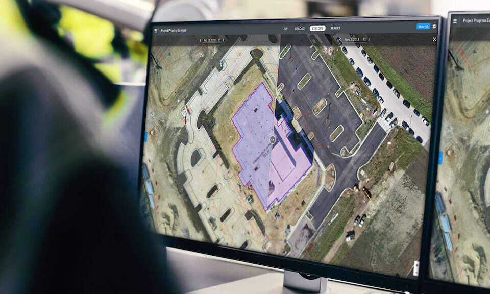
On a construction site, there is always a contractor, an engineering company, an earthmoving company and a number of subcontractors to execute specialized work. In addition to involving a lot of teams, deadlines are tight and require frequently-updated records to drive decisions and align multiple stakeholders. This is where a major advantage of drones lies for construction site managers. Drones provide a complete picture of the construction site on-demand and within a few hours.
The sharp, detailed images produced by drones enable site managers to track work progress and make accurate decisions based on up-to-date data and comprehensive reconstructed site maps instead of relying on plans or incomplete data that may not reflect reality.
The aerial images also act as a visual aid when communicating with all parties, so that everyone can see for themselves what has already been done and what remains to be done.

2. Accurate and comprehensive data
In addition to having detailed aerial photographs, the same data collected by a drone in a single flight provides a complete map of the site with GPS points, in 2D and 3D. These maps allow accurate measurements of distances, surfaces, elevations and volumes. From there, photogrammetry software also generates elevation models such as digital terrain models (DTMs) and digital surface models (DSMs).
With drones, you no longer need to go back to a job site if a data point has been missed. Bacon Farmer Workman (BFW) is an engineering and surveying company in the US Midwest delivering high-quality surveys for clients in construction: “It used to be the case that there would be a landmark, like a manhole, that was missed in a survey. And they’d need the location of it, so someone would have to drive out, set up equipment and get the coordinates of it.” explains Jacob Cash, Mobile Mapping and LiDAR Department Manager at BFW.

3. Cost and time saving
Drones significantly reduce time-intensive data collection in the field and its associated labor costs. Hades Geodeesia, a 30-year-old surveying company is using drones to provide accurate survey data for the construction of a major highway in Estonia: “It doesn’t make sense to go outside and walk for three to four hours and get about 500 points and make calculations.” said Vaiko Veeleid, CEO of Hades Geodeesia. "Instead I can take the drone and fly for a half an hour, process the data, and I get the same or better results than the ordinary way."
Large public works in Norway also benefit a lot from this technology. The Norwegian Public Roads Administration started using drones for regular surveys during road construction.
In the end, drone data saves time and money across all stages of a construction project and for a range of reasons that could be folded into any of the six benefits listed. "Traditionally it would take me about five days in the field with a scanner to get the data we get in an hour with a WingtraOne drone, and then I’d have to edit it inside afterward." says Gry C.S. Kjellsmoen, Chief Engineer at Norwegian Public Roads Administration.
In the end, drone data saves time and money across all stages of a construction project and for a range of reasons that could be folded into any of the six benefits listed.
4. Better documentation and faster reconciliation with subcontractors
Easy and repeated surveying means that the site will have more complete documentation throughout its life cycle.
In cases where a project progresses on top of faulty construction, it’s difficult if not impossible to trace where the mistake was made or who made it. Drone data provides clear, accurate and retrievable documentation at frequent points in the construction process. This allows stakeholders to review and pinpoint where mistakes occurred and settle these disputes out of court since the evidence is clearer.
Another benefit of better documentation is that the data collected can be analyzed to draw lessons from it and compare it for benchmarking purposes.
5. Remote access to current status of the site
BIM managers, surveyors and managers in head offices currently have to either travel physically or rely on workers on site to get information about construction progress. By having somebody on site flying the drone and capturing images, you will be able to see the progress of projects directly on your computer, to evaluate it and discuss it with site managers as if you were on site.
n this way, drones allow managers to have a light point of contact on the activities of their business units in several countries or regions and to obtain information that you would not normally be able to obtain without traveling, or the good will of other individuals.
6. Increased safety
Being able to monitor and inspect hard-to-reach places or areas in the middle of machinery without entering them obviously reduces workers’ exposure to accidents.
Add to this that safety on a construction site is also about securing the work area as accessible only to qualified personnel. So drone imagery can help to locate a breach in the perimeter of a site more quickly, preventing civilian entry and potential accidents.
But the greatest improvements in safety can be found in inspections and maintenance work. Instead of climbing electric poles, using ropes to inspect features of a facility, or working along busy highways, workers can fly a drone and inspect images without putting themselves at risk.
Source: https://wingtra.com/drone-mapping-applications/drones-in-construction-and-infrastructure/


